CHELSEA-STOCKBRIDGE CORRIDOR
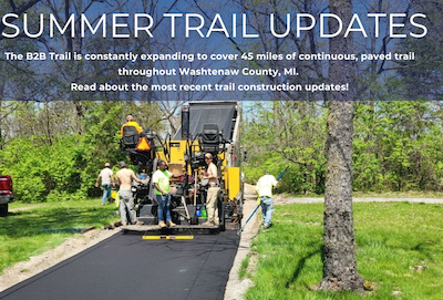
Construction began in 2023 on a new trail segment along the east side of M-52 in Lyndon Township and is expected be completed as of summer 2024. This segment adds 1.6 miles, starting at M-52 and North Territorial, extending to Boyce Road. This project included grading, paving the trail, planting 106 native trees (maple, oak, lindens) and landscape restoration. This project also includes pavement and fence repairs to the existing trail south of the trailhead near the DTE Trail connection.
As of March 2024 a new 108ft concrete boardwalk is in progress. The project is nearly complete. Currently 90% of the concrete is set. This material is a new application on the B2B Trail, with great benefits such as being more cost effective, lasting 3x longer than a wooden boardwalk, and safer during rain events by creating a less icy and slippery surface. The boardwalk is expected to be completed by mid-summer 2024.
We are looking forward to early summer to open this trail segment, bringing us closer to the western Washtenaw County border!
CHELSEA CONNECTION
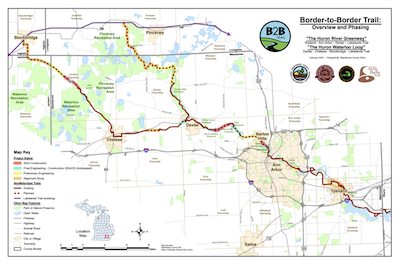
Supported by the MEDC Chelsea Connection Campaign, Phase B of construction has been completed on this 1.1 mile segment is open between Werkner Road and Timbertown/Veteran’s Park.
The North Territorial to Boyce Road segment is not yet open, but is planned to open mid-summer 2024. Once complete, visitors to the Chelsea-Stockbridge corridor will be able to enjoy 6.3 miles of trail from Timbertown to North Territorial. Repair work along the this open section occured this spring, largely repairing failing pavement. Check back for more information!

DEXTER-CHELSEA CORRIDOR
The remaining 0.7 miles from Wylie Road past Parker Road is in-progress, but nearly complete as of summer 2024. This active project will be completed in this summer with the installation of a short bridge to cross a small creek the west of the Miller-Smith Preserve. Construction of 1,000 feet of trail started in 2023 to connect Dancer Road to Miller Smith Preserve and is projected to wrap up this summer.
Looking ahead in 2024/2025, use of the historic Bell Road Bridge to cross Mill Creek as it connects to the trail near Forest Lawn Cemetery will align with an additional 0.8 miles of trail to connect the trail to the City of Dexter. Construction is planned to begin later in 2024 and completed later in 2025. Our construction team is securing easements for the final alignment of the 105-foot wrought iron bridge constructed in 1891.
As we work toward making the final connections between Dexter and Chelsea, parking will be challenging along this segment. Once the corridor is complete, there will be parking and safe public access. Until then, if you do park in this area, please do not use Beacon Hill Drive as it is a private road.
ANN ARBOR-DEXTER CORRIDOR
Construction has begun on the Title IX Plaza: A Women in Sport Journey. Located along the B2B Trail in Dexter-Huron Metropark, the Title IX Plaza is a joint project between WCPARC and HWPI. This project honors the impact of Title IX legislation on women’s sports in southeast Michigan. Construction began spring 2024 with the plaza slated to open in late summer.
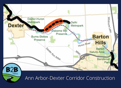
Construction on Phase II of the Zeeb to Delhi trail segment started early spring 2024. Due to warmer than expected weather, our construction team is ahead of schedule with paving and is preparing for setting the bridge by mid-summer 2024.
This project adds 1.3 miles of trail extending from Zeeb Road to East Delhi Road and includes the fourth B2B Trail bridge over the Huron River. This project will complete a total of 4.6 miles of continuous trail east of Dexter toward Ann Arbor and connect all three Metroparks within Washtenaw County!
The Washtenaw County Road Commission is administering this construction project. The latest updates can be found at https://www.wcroads.org/wcrc-project/b2b-huron-river-dr-trail/
ANN ARBOR CORRIDOR
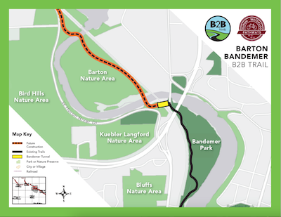
Construction is in progress on a 0.63 Mile segment that will cross the Barton Nature Area.
The Trail Phase of the project started in March with tree clearing. This occurred along the edges of the existing trail and also in the location of the planned pedestrian tunnel. Construction is anticipated to extend into September to grade, put down stone, and pave with concrete. We expect the trails on the oxbow to be closed during this time. There may be temporary closures of other trails as needed during construction. To learn more, read up on the City’s projects happening in this area here.
Looking ahead to 2024/2025, we are excited about the construction of the Barton Bandemer Tunnel which will pass under the railroad line connecting Bandemer Park to Huron River Drive along the B2B Trail.
Amtrak approval is required for the tunnel project to begin, but our partners are working with Amtrak to secure this approval in the coming weeks. We aim to be open for construction bids in mid-May. This project could start construction as soon as early fall 2024 and wrap up 2025.
YPSILANTI CORRIDOR
In Ypsilanti, the project team has collaborated with two City-led initiatives, enhancing small segments of the Border to Border Trail alongside adjacent road and bridge developments. Improvements have been made along Huron River Drive east of LeForge Road, and enhanced non-motorized connections have been coordinated on the Forest Avenue Bridge, located just north of Frog Island Park.
For more information on the Huron Drive project: https://cityofypsilanti.com/887/Huron-River-Drive-Roadwork
For more information on the Forest Bridge project: https://cityofypsilanti.com/892/Forest-Street-Bridge
Looking ahead within the City of Ypsilanti, enhancements to Riverside Park, such as the redevelopment of a trail segment and the expansion of the Depot Town parking lot, are anticipated in the coming years.
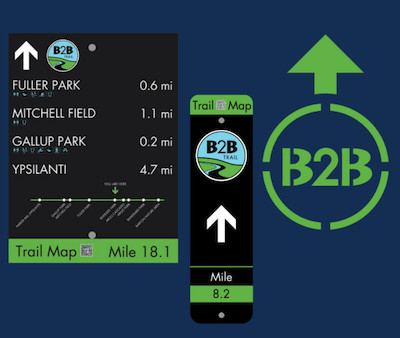
B2B TRAIL WAYFINDING
To improve the usability of the trails for residents and visitors, WCPARC is developing a series of wayfinding signs and structures to be installed across the Border to Border Trail system. Installations are planned to roll out in 2024 and continue over the next couple of seasons. Features will include:
- Primary orientation nodes will be installed at large parking access points with supporting trail amenities where people will be encouraged to park as primary access points. These structures will help to encourage sitting/resting, viewing, and further exploring before heading out on the trail. Content that will go on the primary orientation nodes will include local and regional trail maps, emergency contact information and trail etiquette guides.
- Secondary nodes – Map stations placed at highly visible spots at small parking access points, local access points, and intersecting trails.
- Directional signage will include a linear trail map with mile markers and miles to the next major destination point with amenity notes.
- Blazes will be used frequently on free-standing posts or attached to an existing post.
- Pavement markings will be used on the ground frequently where there is a turn or a choice to be made that could potentially cause users to leave the trail.

